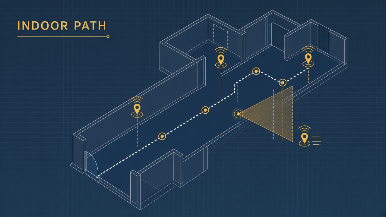
GPS stops at the door. A low-vision traveler enters an unfamiliar airport terminal: identical corridors, echoing announcements, rotating digital signage. Outdoor turn-by-turn apps cannot see through roofs or resolve which gate is fifty meters ahead versus behind a wall. Indoor navigation AI low vision systems fuse venue maps, Bluetooth beacons, visual markers, LiDAR or depth cameras, and spatial audio to describe surroundings and guide steps inside complex buildings. The field spans research pilots, open-source community apps, and commercial deployments in museums and transit agencies.
Mobility instructors and airport accessibility teams evaluating AI chatbot concierge integrations should distinguish outdoor audio navigation (Microsoft Soundscape lineage) from true indoor turn-by-turn with obstacle awareness. More accessibility research appears on the EliteAI.tools blog index.
What Indoor Navigation AI Low Vision Means in Plain Language
Indoor navigation AI low vision refers to smartphone or wearable systems that help blind and partially sighted people orient inside buildings using mapped routes, audio or haptic cues, and sometimes real-time computer vision for landmarks or obstacles. Unlike outdoor GPS navigation, indoor systems rely on proprietary floor plans, Wi-Fi fingerprinting, ultra-wideband (UWB), visual-inertial odometry via ARCore or ARKit, QR codes, passive stickers, or Bluetooth beacons because satellite signals are weak indoors.
Low vision spans a wide range: some users read large print with glare sensitivity; others rely on screen readers and cane travel. Indoor AI must support VoiceOver and TalkBack, offer adjustable speech rate, and never assume full blindness or full sight. Spatial audio (3D cues in headphones) builds mental maps without staring at screens, while high-contrast visual arrows help remaining vision users.
| Technology | How it localizes | Indoor fit |
|---|---|---|
| Bluetooth beacons | Signal strength near fixed transmitters | Strong in instrumented venues |
| Visual markers / QR | Camera reads coded stickers | No batteries; needs line of sight |
| ARCore / ARKit SLAM | Camera plus IMU drift correction | Centimeter accuracy in mapped zones |
| Wi-Fi / UWB fingerprint | Radio pattern matching | Enterprise campus deployments |
Outdoor spatial audio versus indoor wayfinding
Microsoft Soundscape and community successors (VoiceVista, Soundscape by Scottish Tech Army) emphasize outdoor ambient awareness with 3D audio callouts rather than strict indoor turn-by-turn. Microsoft open-sourced Soundscape code so volunteers extended iOS apps and, in 2026, an Android port expanding reach. These tools excel at building confidence on streets; indoor malls and terminals still need venue-specific maps, beacon grids, or marker trails. BlindWays (Perkins School for the Blind) applies beacon haptics to bus-stop micro-navigation, illustrating beacon value for last-meter problems even when full indoor routing is absent.
How the Underlying AI Pipeline Works
An indoor navigation stack ingests floor plans, sensor streams, and user destination, then runs localization, path planning, guidance generation, and optional obstacle detection. Machine learning appears in vision-based marker detection, depth segmentation, pedestrian flow prediction, and natural-language venue search.
Mapping, localization, and computer vision wayfinding
Venue operators supply CAD floor plans or walk-through LiDAR scans converted to navigable graphs (nodes at intersections, edges along hallways). ARCore Depth API and ARKit scene understanding let phones estimate distance to walls and furniture for obstacle warnings in research apps like 3rDi 4 All, which pairs voice turn-by-turn with real-time depth alerts on supported Android hardware. NaviWay uses passive visual stickers detected by the phone camera, avoiding powered beacons while requiring sticker maintenance and camera aiming skill.
AI classifiers recognize doors, escalators, and signage in pilot airport programs, though generalization across global terminal designs remains hard. Semantic segmentation models flag temporary construction barriers if training data includes similar occlusions.
Path planning and multimodal guidance
Graph search (A*, Dijkstra) finds accessible routes respecting elevators, tactile paving, and avoided stairs when user profiles demand. Adaptive potential field methods adjust paths when dynamic obstacles appear in camera view. Guidance layers render as sequential audio instructions ("turn left in ten meters"), rhythmic beacons that grow louder when heading correctly (Soundscape Audio Beacon pattern), or haptic pulses on smart canes paired via Bluetooth.
Large language models assist venue Q&A ("Where is the nearest accessible restroom?") when connected to structured POI databases, but LLM hallucination risk requires grounding every answer in verified map IDs. Chatbot layers should not invent gates or room numbers.
| Component | AI role | Failure mode |
|---|---|---|
| Marker detection | CNN / mobile vision models | Missed stickers in low light |
| SLAM drift | Loop closure, map matching | Position error after long walks |
| Obstacle depth | Depth API segmentation | Glass / low contrast objects |
| POI search | Semantic retrieval over maps | Outdated store directory |
Typical deployment workflow
- Co-design with blind and low-vision travelers and orientation mobility specialists.
- Instrument pilot zone: beacons, stickers, or SLAM walk-through plus accessible route graph.
- Integrate with screen reader APIs and test speech rate, language, and headphone spatialization.
- Run day-night trials for glare, crowd density, and construction changes.
- Publish map update pipeline and staff training for sticker replacement or beacon battery checks.
- Measure success: time to destination, wrong-turn count, subjective confidence scales.
Real Deployments and Published Evidence
eZwayZ deploys inclusive indoor navigation at Dutch cultural sites including the Rijksmuseum and NEMO Science Museum, offering route guidance and audio descriptions without heavy infrastructure retrofits according to vendor case studies. NaviWay pilots in Polish public buildings (Gdynia city facilities) highlight universal design for blind, low-vision, senior, and neurodivergent visitors using sticker-based markers.
U.S. airport accessibility programs periodically trial indoor wayfinding apps with airlines and disability advocacy groups; coverage is patchy and often limited to single terminals. Mall operators experiment with white-label apps tied to directory kiosks, though maintenance lags when tenants churn. Transit agencies pair outdoor Soundscape-style awareness with BlindWays beacon haptics at bus stops, solving complementary last-meter problems.
Academic prototypes on ARCore and HoloLens demonstrate spatial mesh audio ("hearing" room geometry) and haptic belts signaling direction. Peer reviews note none achieve one hundred percent reliability; cane skills and human assistance remain essential backups. Google Indoor Maps and Apple Maps indoor floor plans help sighted users but historically offer limited turn-by-turn for blind travelers unless third-party apps layer accessibility features on top.
Airport and mall pilot lessons
Pilots that succeed share traits: disability-led UX, on-site mobility trainer office hours, redundant tactile signage, and SLA for map updates when gates shift. Pilots that fail often treat navigation as a one-time demo without beacon battery budgets or sticker vandalism plans. Crowd noise interferes with spatial audio unless bone-conduction headphones or directional mics are tested.
San Francisco International Airport and other U.S. hubs have experimented with indoor wayfinding partnerships, though coverage rarely spans entire multi-terminal complexes. Mall operators such as Westfield have tested white-label apps tied to directory APIs, but tenant turnover breaks POI accuracy unless stores confirm map pins quarterly. Computer vision wayfinding research at universities pairs ARCore localization with haptic vests or smart canes, showing promise in lab corridors but demanding calibration per building wing.
BlindWay-style beacon haptics at transit stops demonstrate that vibrating proximity cues help confirm arrival without reading small text signs. The same haptic pattern language could mark elevator banks or restroom doors indoors if venues install low-cost transmitters. Until standardized indoor POI schemas exist, travelers should verify which app covers which building wing before relying on a single download.
Limits, Risks, and Ethical Guardrails
Indoor AI navigation cannot replace white cane skills, guide dogs, or human assistance for dynamic hazards like silent electric carts or wet floors. Overpromising independence risks safety incidents and liability for venue owners.
- Digital divide: Smartphone and data plan requirements exclude some travelers.
- Map staleness: Renovations invalidate routes faster than outdoor map updates.
- Privacy: Continuous camera SLAM raises surveillance concerns in sensitive sites.
- Vendor lock-in: Proprietary beacon networks strand users when apps sunset.
- Equity: Premium airports deploy tech while rural transit stops lack basic tactile maps.
Ethical deployment open-sources map data where possible, supports standard POI schemas, and funds maintenance budgets alongside launch PR. WCAG and ADA Title III push physical access; digital indoor wayfinding should be procured with accessibility acceptance tests, not marketing demos alone.
Who Should Use This and Who Should Wait
Airport authorities, museum accessibility leads, hospital wayfinding teams, and campus facilities managers with ongoing map stewardship should pilot marker or beacon systems co-designed with low-vision users. Individual travelers can adopt Soundscape-community outdoor tools plus venue-specific apps when available. Small retailers without maintenance staff should wait on custom beacon mesh and instead ensure human wayfinding and clear tactile paths.
| Setting | Recommendation | Guardrail |
|---|---|---|
| Large museum | Sticker or app layer plus audio descriptions | Staff trained on app support |
| Airport terminal | Pilot one concourse with beacons + human escort backup | Publish coverage map honestly |
| Office campus | Wi-Fi fingerprint or UWB if IT budget exists | Sync with elevator outages |
| Personal travel | Combine outdoor spatial audio with venue app research pre-trip | Carry low-tech backup plan |
Frequently Asked Questions
Why does GPS fail indoors?
Satellite signals attenuate through roofs and walls, and multipath error prevents meter-level indoor positioning. Indoor systems use beacons, visual markers, SLAM, or radio fingerprinting instead.
Can Microsoft Soundscape navigate inside malls?
Soundscape focuses on outdoor spatial audio awareness; indoor turn-by-turn generally requires separate venue apps or markers. Open-source Soundscape code powers community apps but not universal indoor routing.
Is BlindWays an indoor navigation app?
BlindWays targets bus-stop micro-navigation using crowdsourced clues and Bluetooth beacons, not full building routing. Beacon lessons transfer to indoor last-meter problems.
How accurate is ARCore indoor positioning?
Research prototypes report centimeter-level SLAM accuracy over short distances, but drift and device support limits vary. Obstacle depth APIs miss glass and thin objects.
Beacons or visual stickers?
Beacons offer passive proximity without aiming a camera but need batteries and installation; stickers are cheap and battery-free but require camera line of sight and maintenance. Hybrid deployments appear in NaviWay geo-zones.
Should venues use LLM chatbots for wayfinding?
LLMs should retrieve answers from verified map databases only; unconstrained generation can invent gate numbers or room names. Human staff escalation remains mandatory.
Are indoor navigation apps regulated?
Most consumer wayfinding apps are not medical devices, but safety-critical hospital deployments may face facility liability review. ADA physical access rules complement but do not replace app quality testing.
Conclusion
Indoor navigation AI low vision combines mapped graphs, beacons or visual markers, ARCore and ARKit SLAM, spatial audio, and optional depth-based obstacle alerts to extend independence inside airports, malls, museums, and transit hubs. Microsoft Soundscape's open-source lineage improves outdoor awareness; indoor turn-by-turn remains venue-specific with examples like NaviWay, eZwayZ, and research ARCore pilots. No system replaces cane travel or human assistance today. Successful deployments co-design with low-vision travelers, fund map maintenance, and communicate coverage limits honestly. Built with those guardrails, indoor AI wayfinding narrows the gap between the street door and the destination room.