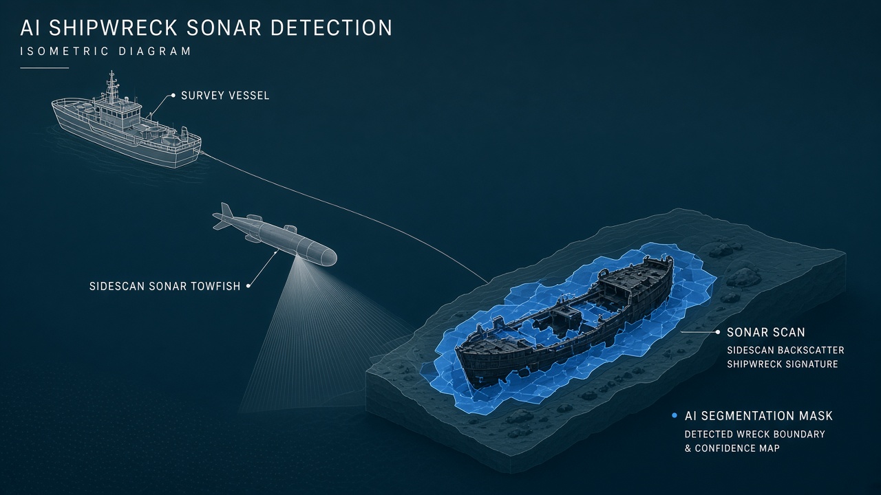
AI shipwreck detection from sonar applies segmentation and object-detection models to multibeam bathymetry and sidescan mosaics, with open tools like ShipwreckFinder and DFSE-YOLO achieving usable accuracy on Great Lakes, Irish coastal, and Thunder Bay National Marine Sanctuary datasets. Machine learning reduces analyst hours spent ruling out geological false positives, but legal protections for submerged cultural heritage, military wreck sensitivities, and treasure-hunting incentives constrain how detections may be acted upon. Teams following AI research on geospatial perception or AI research infrastructure for marine robotics should pair model deployment with maritime archaeology ethics review.
Sonar Survey Basics for Lay Readers
Multibeam sonar maps seafloor depth in swaths, producing bathymetry rasters where hulls often appear as localized depressions or protrusions; sidescan sonar captures acoustic backscatter imagery where wrecks cast distinctive shadows. Optical cameras fail beyond tens of meters in turbid coastal water, so archaeologists rely on sound. Survey vessels tow sidescan fish or mount multibeam heads on hulls, logging GPS-tagged tiles that mosaic into gigapixel maps. Each pixel encodes depth or intensity, not color photography.
Wreck signatures vary: wooden hulls may collapse into low mounds; iron steamers create sharp rectangular shadows on sidescan; fishing gear and geology mimic targets. Human analysts traditionally scroll mosaics for hours, flagging anomalies for diver verification. AI automates first-pass screening, ranking tiles by wreck probability before expensive ROV or diver missions.
NOAA and university groups contribute labeled examples from sanctuaries such as Thunder Bay in Lake Huron, where nearly 100 known wrecks and many undiscovered sites create rich training material. The open AI4Shipwrecks dataset packages 286 high-resolution sidescan images covering 28 distinct wrecks for benchmarking segmentation models on autonomous underwater vehicle surveys.
Labeling Wreck vs Geology False Positives
Supervised wreck detectors learn from pixel masks or bounding boxes drawn by archaeologists; false positives arise when rocky outcrops, pipelines, and kelp beds resemble hull geometry. ShipwreckFinder trains U-Net, U-Net-Hillshade, HRNet, and BASNet backbones on multibeam data from the Great Lakes and Irish coasts, comparing against classical inverse sinkhole detectors and commercial ArcGIS toolkits. Label quality matters more than backbone choice: inconsistent masks on partially buried timbers teach models to ignore valid low-contrast sites.
DFSE-YOLO targets sidescan imagery with a lightweight selective feature enhancement block that spends compute on semantically rich deep layers while skipping shallow layers, reaching 0.7551 mAP50 on AI4Shipwrecks with 40.1 FPS inference and a 5.25 MB model suited to edge deployment on survey AUVs. Acoustic shadows and seabed reverberation remain hard cases where human review is mandatory.
Active learning loops help: when the model flags an anomaly, analyst confirmation feeds back into retraining. Without that loop, geology-heavy regions produce alert fatigue and missed shallow wooden wrecks with subtle relief. Synthetic augmentation of rare hull orientations improves recall but risks unrealistic sonar noise profiles if not validated against field tiles.
| Tool or model | Sonar type | Notable metric |
|---|---|---|
| ShipwreckFinder (QGIS) | Multibeam bathymetry (BAG, XYZ, TIFF) | Open plugin, OCEANS 2025 paper |
| DFSE-YOLO | Sidescan sonar mosaics | 0.7551 mAP50, 40.1 FPS |
| AI4Shipwrecks benchmark | Sidescan, 28 wrecks, 286 images | Public segmentation labels |
| Classical sinkhole detection | Multibeam derivatives | Baseline in ShipwreckFinder eval |
Transfer Learning Across Ocean Basins
Models trained on freshwater Great Lakes wrecks do not always transfer to saltwater carbonate shelves without fine-tuning because seabed backscatter and burial patterns differ. Transfer learning across ocean basins requires re-labeling representative tiles from the target region, adjusting depth normalization, and testing on held-out wrecks with documented ground truth. ShipwreckFinder mitigates domain shift partly by mixing Irish and Great Lakes tiles during training, but tropical coral rubble and volcanic sand remain underrepresented in public sets.
Military exclusion zones and classified surveys limit open data for some high-interest regions. Researchers should document geographic bias when publishing detection rates. A 75 percent mAP50 in Lake Huron does not promise equivalent recall on the North Sea without local validation dives.
Satellite-derived bathymetry helps coarse regional planning but lacks resolution for wooden wreck ribs. AI shipwreck detection sonar ML still depends on vessel-towed sensors for confirmation. Fusion workflows stack satellite sinkhole hints with multibeam follow-up tiles, using the cheap layer to steer expensive survey lines rather than replacing them.
Training data bias toward intact iron hulls under-represents burned wooden traders common in early modern Southeast Asian routes. Augmenting datasets with simulated collapsed timber scatter may improve recall if validated against known archaeological case files. Without domain expert review, synthetic wrecks teach texture artifacts that fail on real mud-buried decks.
Foundation sonar encoders pretrained on broad seafloor categories may eventually reduce per-region labeling burden, but wreck-positive pixels are rare compared with mud and rock. Semi-supervised methods that treat unlabeled survey tiles as negative examples help only when those tiles are confirmed wreck-free, which is rarely guaranteed on unexplored blocks.
Legal Status of Discovered Wrecks
Many jurisdictions treat submerged wrecks as protected heritage regardless of discovery method; unauthorized salvage, artifact removal, or public coordinate disclosure can violate national laws and UNESCO principles. The United States Abandoned Shipwreck Act assigns title to states for certain historic wrecks in territorial waters. Military vessels often remain sovereign property with restricted access. European waters blend national heritage statutes with EU underwater cultural heritage directives. AI detections therefore trigger legal review before publicity or commercial exploitation.
Treasure-hunting firms may misuse open models to prioritize salvage targets. Responsible research groups coordinate with heritage agencies, embargo precise coordinates in public releases, and refuse partnerships that monetize looting. Academic papers should discuss ethics alongside mAP scores when presenting shipwreck detection sonar ML workflows.
Indigenous and descendant communities may claim stewardship over wrecks tied to migration, slavery, or naval conflict. Consultation protocols should precede diver intervention, especially when human remains may be present. Machine learning accelerates finding sites; it does not replace consent processes.
Museum and Preservation Workflows
After AI flags a candidate site, maritime archaeologists run verification surveys, in situ documentation, and conservation planning before any disturbance. Museums increasingly archive sonar mosaics alongside artifact catalogs, linking detection model version hashes to each survey expedition for reproducibility. Preservation favors in situ protection when excavation risks destroying context. ML prioritization helps allocate limited diver days to high-probability anomalies with historical significance rather than random grid searches.
Integration with GIS layers (sanctuary boundaries, fishing zones, cable routes) prevents false chase of known infrastructure. ShipwreckFinder outputs segmentation masks and optional bounding boxes importable into QGIS for overlay with NOAA charts. DFSE-YOLO bounding boxes feed AUV replanning loops that zoom sidescan resolution on promising shadows during the same mission.
Long-term monitoring compares repeated surveys to detect sediment burial or trawl damage. Change detection atop wreck detectors alerts managers when previously visible hull sections disappear under shifting sand, informing protective buffer requests to fisheries regulators.
NOAA Thunder Bay National Marine Sanctuary partnerships demonstrate how labeled sidescan mosaics seed academic benchmarks while sanctuary managers retain stewardship authority. University groups publishing AI4Shipwrecks derivatives should credit sanctuary staff who drew masks on difficult tiles. Citizen science programs training recreational divers to validate low-confidence detections extend labeling capacity but require liability waivers and heritage training on non-disturbance principles.
Edge deployment on AUVs demands thermal and power budgeting: DFSE-YOLO's 5.25 MB footprint suits onboard inference, yet storage for raw sonar tiles may fill vehicle disks before upload windows open at surface. Mission planners trade off real-time reroute versus post-mission batch inference on shore clusters. Hybrid architectures run a tiny detector at sea and a heavier segmentation model after recovery when analysts have time to QC masks before entering national heritage databases.
Survey contractors bidding government marine mapping contracts should disclose whether AI wreck screening runs on every tile or only on analyst-flagged subsets. Transparent reporting prevents overstated discovery claims when a model merely re-found cataloged hulks. Pairing shipwreck detection sonar ML with automatic report generation that cites model version, training geography, and confidence histograms helps procurement officers compare vendors on reproducibility, not marketing slides alone.
Public outreach should explain that AI detections start hypotheses, not treasure maps. Heritage agencies using ShipwreckFinder or DFSE-YOLO internally still owe divers and descendant communities the same care as manual surveys. Transparent reporting of false positive rates on geology-rich tiles builds trust better than headline counts of newly found wrecks before verification dives complete.
Cold-water versus warm-water biofouling changes sidescan appearance: Great Lakes wrecks often present sharper hull shadows than coral-encrusted Caribbean sites where biology softens edges. Transfer learning checklists should include seasonal repeat surveys because ice scour and storm burial alter signatures year to year. Archaeologists treating ML as a prioritization layer rather than autonomous discovery avoid ethical lapses when coordinates might expose fragile wooden wrecks to anchor damage.
Frequently Asked Questions
Can AI find deep-ocean wrecks?
Models work on any sonar mosaic with sufficient resolution. Depth limits come from survey hardware and funding, not the neural network. Abyssal surveys remain rare in public training data.
Are military wrecks included in public datasets?
Sanctuaries emphasize civilian heritage; many naval wrecks stay classified or restricted. Do not assume public benchmarks represent military search scenarios.
Does AI shipwreck detection encourage looting?
It can if coordinates leak without safeguards. Heritage-first workflows embargo precise locations and partner only with licensed archaeologists.
What sonar format does ShipwreckFinder accept?
The QGIS plugin ingests BAG, XYZ, and TIFF bathymetry rasters, preprocesses hillshade derivatives, and runs selectable segmentation backbones.
How accurate is DFSE-YOLO?
On AI4Shipwrecks it reports 0.7551 mAP50, outperforming YOLOv8 and YOLOv11 baselines by roughly five percentage points in published January 2026 results.
Do NOAA datasets cover all U.S. waters?
Coverage is uneven. Thunder Bay and other sanctuaries are well sampled; much of the outer continental shelf lacks labeled wreck mosaics suitable for training.
Where should I follow underwater ML research?
OCEANS conference proceedings and open repositories such as AI4Shipwrecks publish benchmarks. For broader perception trends, see AI research on geospatial and robotics applications.