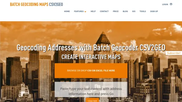
What is CSV2GEO?
CSV2GEO is a robust online platform designed for efficient batch geocoding and reverse geocoding services. It empowers users to convert large lists of street addresses into precise geographic coordinates (latitude and longitude) or, conversely, transform coordinates back into well-formatted addresses. The tool is adept at handling data from various sources, including CSV files, Excel spreadsheets, or directly pasted text, facilitating a streamlined workflow for professionals across diverse industries.
Beyond mere data conversion, CSV2GEO excels in creating and publishing interactive maps from the processed geographic information. This feature allows for dynamic visualization and analysis of spatial data, complete with options for customization such as unique map markers, data filtering, and custom annotations. The platform emphasizes accuracy, providing live, real-time geocode conversions for rooftop-level precision, and offers an API for developers seeking to integrate its geocoding capabilities into their own applications.
Features
- Batch Geocoding: Convert large lists of worldwide addresses into latitude and longitude coordinates with high accuracy.
- Reverse Geocoding: Transform geographic coordinates (latitude and longitude) into well-formatted street addresses.
- Interactive Map Generation: Create, publish, and share dynamic interactive maps from geocoded data.
- Flexible Data Input: Supports data import via CSV files, Excel spreadsheets, or direct text pasting.
- Map Customization: Offers tools to personalize maps with unique markers, color-coding, data filters, custom icons, and notes.
- API Access: Provides an API for integrating geocoding and map generation functionalities into other applications.
- Rooftop Accuracy: Delivers precise geocoding results, often down to the rooftop level, through live conversions.
Use Cases
- Civic and Political Activism: Mapping supporters, planning campaign routes, or visualizing petition data.
- Financial Services: Tracking and assessing project locations and engagements for banks or advisory institutions.
- Journalism: Visualizing data related to news stories and investigations on interactive maps.
- Education and Research: Supporting academic projects and research requiring geographic data analysis.
- Supply Chain and Logistics: Optimizing delivery routes and managing company inventory by geolocating assets.
- Real Estate: Analyzing property locations, market trends, and creating visual property listings.
FAQs
-
How does CSV2GEO handle different address formats?
CSV2GEO allows users to dynamically associate one or more file columns to six major address components (street number, street, city, state/province, zip/postal code, country/region), offering flexibility for various address token arrangements. -
Is there a limit to the free geocoding service?
Yes, CSV2GEO processes the first 100 geographical addresses for free. For larger datasets, payment is required only for valid processed records. -
What kind of accuracy can I expect from CSV2GEO?
CSV2GEO aims for high accuracy by providing online geocoding rooftop results through live conversions, using one of the most accurate map engines. -
Can I customize the maps created by CSV2GEO?
Yes, users can customize interactive maps by designating unique color map markers, filtering by list columns and values, setting up marker icons from a library, marking visited map markers, and adding custom notes. -
What input file formats are supported for batch processing?
CSV2GEO accepts CSV files (UTF-8 compliant), Excel files, or text pasted directly into the tool for batch geocoding or reverse geocoding.