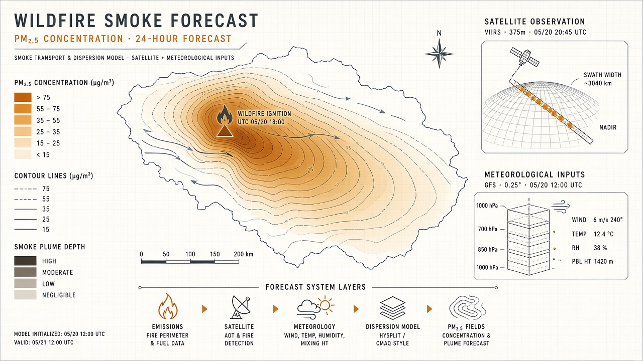
Wildfire smoke now drives some of the worst air quality days in North America, Alaska, and increasingly temperate Europe. Predicting where fine particulate matter (PM2.5) will land requires coupling fire emissions, atmospheric transport, boundary layer mixing, and sometimes machine learning corrections on top of physics-based models. NOAA's High-Resolution Rapid Refresh Smoke (HRRR-Smoke) module runs inline with convection-allowing weather prediction at roughly three-kilometer resolution. Recent studies apply neural networks and random forests to bias-correct HRRR-Smoke surface PM2.5, cutting underestimation factors from fivefold to twofold or less in Alaska wildfire seasons. For public health planners and readers following AI research on environmental forecasting or exploring popular AI tools that surface air quality data, understanding smoke physics plus ML post-processing clarifies why apps sometimes disagree and when to trust hourly guidance.
Smoke Transport Physics in Brief
Smoke forecasting begins with estimating emissions from active fires, lofting plumes into the atmosphere, and advecting particles with winds while chemistry and deposition remove mass. Fire radiative power detections from satellites constrain heat release and injection height, but heavy smoke or cloud cover can obscure sensors, leading to missed emissions. Once aloft, smoke transport follows mean winds and turbulent mixing; near-surface concentrations depend critically on vertical distribution. A plume trapped aloft may produce clear skies locally while communities hundreds of kilometers downwind see hazardous PM2.5 when the layer descends.
HRRR-Smoke couples these processes to hourly meteorology so smoke evolves with evolving winds and inversions. Temperature inversions, common during stable nighttime or certain daytime fire regimes, cap smoke near the ground and spike local concentrations. Models that misrepresent inversion strength or miss fire intensity under cloudy scenes systematically underestimate surface PM2.5, a pattern documented in Alaska bias correction research published in ACS ES&T Air in 2025 (doi:10.1021/acsestair.5c00409). Physics remains essential; machine learning typically refines outputs rather than replacing conservation laws.
Chemical transport models such as GEOS-CF, CAMS, and NOAA NAQFC also provide PM2.5 guidance internationally. Comparative studies in BAMS 2026 evaluate whether hourly forecasts help individuals plan outdoor exposure during high pollution days. Some models cut excess PM2.5 exposure when used to schedule activities, yet morning monitor readings alone rival forecast skill for simple go-or-no-go decisions. That nuance matters for public messaging: forecasts add most value for anticipating tomorrow's plume direction, not replacing today's sensor reality.
Data Sources: Satellites, Fires, Weather
Operational smoke pipelines ingest satellite fire detections, land fuel and emissions inventories, numerical weather prediction fields, and ground monitors for calibration. Polar-orbiting and geostationary sensors supply fire radiative power and aerosol optical depth; MODIS and VIIRS family products appear frequently in validation studies. Surface networks including EPA AirNow and community PurpleAir sensors provide ground truth, though PurpleAir requires correction algorithms before use in model training. Atmospheric soundings reveal inversion layers that explain when models underpredict near-surface smoke despite realistic column aerosol loading.
| Input | Typical source | Forecast role |
|---|---|---|
| Fire intensity | Satellite FRP, perimeter maps | Drives emission rate and plume height |
| Meteorology | HRRR winds, stability, precipitation | Advects and mixes smoke |
| Column smoke | HRRR-Smoke vertical mass layers | Links aloft plumes to surface |
| Ground PM2.5 | AirNow, corrected PurpleAir | Trains ML bias correction |
ML Correction to Physics Models
Machine learning bias correction learns systematic errors in physics-based smoke forecasts from historical pairs of model output and observed PM2.5, then adjusts new forecasts at inference time. The Alaska study compared random forest, one-dimensional CNN, and two-dimensional CNN models using predictors including HRRR-Smoke surface and vertical smoke fields, calibrated PurpleAir observations, atmospheric soundings, and aerosol optical depth. CNN1D performed best, reducing chronic underestimation during peak wildfire weeks. Errors correlated with misallocated vertical smoke mass and missed daytime inversions linked to absent fire detections under opaque clouds.
California mapping work fusing three-kilometer HRRR-Smoke with monitor data via random forest reported strong held-out metrics (MAE 0.541 micrograms per cubic meter, R-squared 0.936) for six-hourly statewide fields, illustrating ML as a downscaling and bias removal layer atop operational smoke products. Pure AI foundation models such as Microsoft Aurora can underperform traditional physical forecasts for PM2.5 when trained without direct wildfire inputs or ground monitors, according to analysis in the Bulletin of the American Meteorological Society (2026, BAMS-D-24-0291). Effective hybrids combine physics transport with ML trained on observations at smoke-relevant temporal resolution, hourly where possible.
Uncertainty and Ensemble Forecasts
Smoke forecasts carry uncertainty from fire growth, wind errors, and vertical mixing, best communicated through ensembles, lagged runs, or probabilistic exceedance maps rather than single deterministic lines. Small shifts in plume height change downwind cities by hundreds of kilometers. Ensemble weather prediction can bracket transport scenarios; multi-model means such as HAQES do not automatically beat the best single model in every region, so users should treat consensus cautiously. Research on hourly PM2.5 guidance finds many forecasts help plan outdoor activity timing on high pollution days, yet morning observations alone sometimes perform as well as same-day forecasts for binary go-or-stay decisions, highlighting limits for very short-fuse planning.
Climate change lengthens fire seasons and increases burned area in many regions, amplifying smoke forecast demand. Models must refresh fire inputs as new ignitions appear; stale perimeter files produce ghost plumes or miss new corridors. Uncertainty communication should distinguish model spread from monitor gaps in rural areas where smoke impacts may exceed sparse sensor coverage.
How Alerts Reach Phones and Schools
Public smoke guidance flows from national agencies through AirNow, state dashboards, and third-party apps that ingest EPA Air Quality Index categories translated from PM2.5 concentrations. Wireless emergency alerts for air quality deploy in some jurisdictions when short-term forecasts predict prolonged unhealthy levels, though policies vary by state and tribe. Schools consult district protocols tied to AQI thresholds for recess, sports, and HVAC modes. Health departments recommend N95 or equivalent masks when AQI exceeds unhealthy categories, especially for children and respiratory patients.
App users often see blended feeds merging monitor observations, nowcasts, and multi-day smoke model outputs. Discrepancies arise when apps use different underlying models, correction layers, or lagged fire inputs. Checking local monitor trends alongside forecast plumes helps interpret conflicting messages. Researchers advancing AI research in this space should prioritize observational fine-tuning and wildfire-aware features over generic weather foundation models alone.
Schools and sports leagues increasingly codify AQI thresholds in athletic handbooks. When smoke arrives mid-season, administrators need same-day guidance that reflects both forecast plumes and real-time monitor spikes near campus air intakes. Health equity concerns arise when low-income neighborhoods lack monitors yet sit downwind of recurring fire corridors; ML downscaling can extrapolate concentrations but increases uncertainty where no ground truth exists.
Frequently Asked Questions
What is HRRR-Smoke?
HRRR-Smoke is NOAA's inline smoke prediction module within the High-Resolution Rapid Refresh weather model, providing roughly three-kilometer, hourly smoke transport and near-surface concentration fields over the United States and adjacent domains in operational configurations.
How accurate are smoke forecasts?
Accuracy varies by region, fire activity, and lead time. Physics models can underestimate surface PM2.5 by large factors during intense events; ML bias correction and newer emissions inputs improve but do not eliminate error. Treat multi-day plume location as directional guidance, not street-level certainty.
Does climate change affect smoke forecasts?
Longer fire seasons and larger fires increase smoke frequency and challenge models trained on historical distributions. Forecast systems must update fire weather climatologies and fuel datasets to remain calibrated.
Should I trust phone app AQI?
Prefer apps sourcing EPA AirNow or state environmental agencies when available. Compare forecast AQI with nearby monitor trends; if monitors already show hazardous levels, do not wait for a delayed model update to take protective action.
Which mask for wildfire smoke?
Health agencies recommend N95 or KN95 respirators for fine particulate filtration during outdoor exposure in unhealthy air. Cloth masks do not adequately filter PM2.5. Follow local public health guidance for sensitive groups and indoor sheltering.
When do emergency alerts fire?
Air quality wireless alerts depend on jurisdictional rules forecasting sustained unhealthy categories. Not all regions deploy them; subscribe to local alert systems and monitor school district communications during active fire weather.
Long-term smoke exposure studies link repeated PM2.5 spikes to cardiovascular and respiratory morbidity, so forecast improvements are public health infrastructure, not convenience features. Agencies publishing AI-corrected layers should document training windows and monitor networks so downstream apps can explain why today's map differs from yesterday's uncorrected HRRR-Smoke baseline.
Fire managers coordinating prescribed burns and suppression also consume smoke forecasts to minimize downwind public health impacts. When ML correction layers adjust surface PM2.5 upward during inversion events, evacuation timing for sensitive populations improves relative to raw model guidance alone, provided fire perimeter inputs refresh hourly during rapidly spreading incidents.
Alaska bias correction research in ACS ES&T Air (2025) demonstrates that CNN1D models ingest vertical smoke mass, sounding profiles, and calibrated low-cost sensor networks jointly. Similar architectures could transfer to western CONUS fire seasons where PurpleAir density exceeds official monitor spacing, though retraining is mandatory because inversion climatologies differ by region. Ensemble means of multiple physics models do not automatically outperform the best single member during extreme smoke weeks, so ML layers should target known bias signatures rather than averaging away sharp plume edges.
Smoke forecast consumers should note product lead times: HRRR-Smoke runs inline with hourly weather cycles, but fire perimeter updates may lag active incidents unless integrated from incident command systems. ML correction cannot fix missing ignitions in the prior six hours; it only adjusts bias conditional on the physics model's plume structure.
Public health agencies translating PM2.5 forecasts into advisory language should align category breakpoints with EPA Air Quality Index definitions so ML-corrected maps do not confuse users trained on monitor-only apps. When CNN1D bias correction reduces underestimation during Alaska wildfire seasons, advisory text should note that corrected layers incorporate PurpleAir and sounding data unavailable to uncorrected HRRR-Smoke viewers.