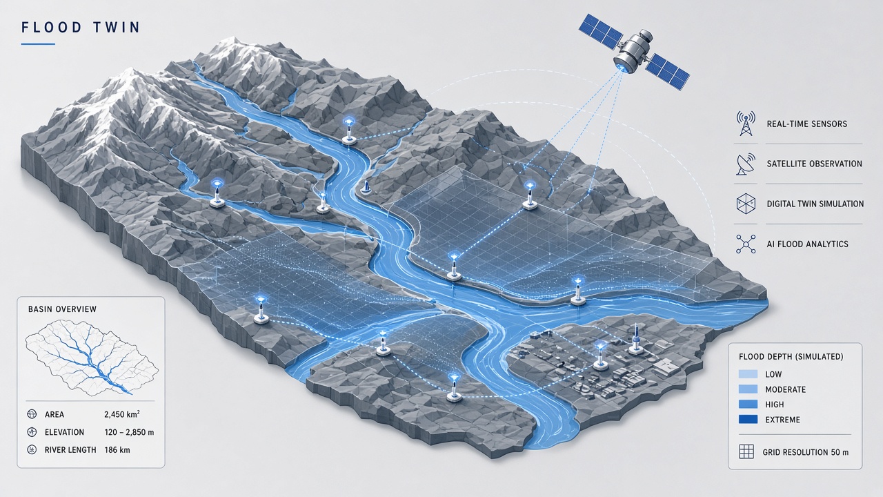
When heavy rain falls on a river basin, emergency managers need more than a weather forecast. They need to know which neighborhoods flood first, whether levees overtop, and how long high water persists. Traditional hydrologic models solve physics equations on fixed grids but struggle to ingest live satellite observations and learn from historical event catalogs at scale. Flood digital twin AI couples physics-based simulators with machine learning so a virtual copy of the watershed updates continuously and forecasts inundation with quantified uncertainty.
Municipal resilience offices, reinsurance analysts, and transportation planners increasingly request digital twin language in procurement documents. Teams evaluating AI chatbot interfaces for citizen hazard reporting should connect chat flows to authoritative gauge and model APIs, not hallucinated flood depths. Additional technical explainers sit on the EliteAI.tools blog index.
What Flood Digital Twin AI Means in Plain Language
A flood digital twin is a continuously updated computational replica of a river basin that assimilates observations (rainfall, river stage, satellite inundation) and runs forecast scenarios; AI accelerates calibration, routing, and data fusion inside that replica. "Digital twin" implies bidirectional sync: real sensors update the model, and the model predicts future states that guide decisions in the physical world. AI enters as neural network emulators of slow physics solvers, graph networks that learn channel connectivity, and CNN-LSTM hybrids that map radar rain to discharge.
Unlike a static FEMA flood map, a twin runs in near real time during storms. Unlike a pure black-box LSTM, a physics-informed twin conserves mass and respects boundary conditions. The synthesis is what procurement teams now label "flood digital twin AI."
| Component | Role in twin | AI contribution |
|---|---|---|
| Hydrologic model | Rainfall to runoff transformation | Parameter learning, bias correction |
| Hydraulic routing | Channel and floodplain flow | Differentiable CNN routing (DHFM) |
| Data assimilation | Merge model with observations | Sentinel-1 SAR inundation updates |
| Forecast layer | Future water levels | PI-GNN, CNN-LSTM emulators |
How the Flood Digital Twin Pipeline Works
A river basin flood digital twin pipeline builds a terrain and channel mesh, calibrates hydrologic and hydraulic parameters, ingests numerical weather prediction and radar rainfall, assimilates satellite and gauge observations each timestep, and publishes deterministic and ensemble inundation forecasts. AI shortcuts appear where full physics solves are too slow for operational deadlines.
Luxembourg Sentinel-1 assimilation
Researchers building a national-scale flood digital twin for Luxembourg integrated Sentinel-1 synthetic aperture radar inundation maps into the forecasting loop. Data assimilation nudges model states toward satellite-observed wet areas, reducing flood extent error by 15% to 33% compared to open-loop simulations in published case studies. SAR sees through clouds, critical for European winter storms when optical satellites fail.
Physics-informed graph neural networks
Physics-informed Graph Neural Networks (PI-GNN) embed conservation laws into GNN message passing so river nodes exchange water consistent with channel geometry. Reported skill on benchmark rivers includes critical success index (CSI) of 0.89 and root mean square error (RMSE) of 0.18 m for 72-hour stage forecasts, competitive with calibrated hydrodynamic models at fractionally lower compute once trained.
CNN-LSTM on the Hyodon River
Hybrid CNN-LSTM architectures extract spatial rainfall patterns via convolutional layers and temporal memory via LSTM units to predict discharge hydrographs. On South Korea's Hyodon River basin, published work reports F1 scores of 0.98 for flood event classification, reflecting strong separation of flood versus non-flood periods when radar inputs align with gauge locations. Such classifiers often gate emergency workflows before full 2D inundation maps finish computing.
DHFM differentiable hydrologic routing
Differentiable Hydrologic Flow Models (DHFM) use convolutional neural networks to approximate routing operators while remaining end-to-end trainable with observed hydrographs. Gradients flow back through routing, enabling joint optimization of rainfall-runoff and channel parameters that traditionally require manual calibration. DHFM fits inside digital twins that must retrain after land cover change or urban expansion.
Ensemble forecasts and public communication
Operational twins increasingly publish ensemble spreads: dozens of rainfall scenarios from numerical weather prediction perturbations drive multiple inundation realizations. Emergency managers see probability of exceedance maps (10%, 50%, 90% flood depth) rather than a single deterministic line on a map. AI emulators accelerate ensemble generation because running a full 2D hydraulic solve forty times per forecast cycle exceeds cluster budgets for mid-size cities. Public-facing dashboards must translate ensembles into actionable language ("prepare for flooding in low-lying streets along River Road") without hiding uncertainty behind false precision.
Coupling weather and hydrology models
Twin performance depends on upstream quantitative precipitation forecasts. A perfect hydraulic mesh cannot compensate for a misplaced rain band in the weather model. Data assimilation of weather radar during events nudges short-term rainfall fields before they propagate into river routing. Machine learning bias correction layers between weather ensembles and hydrologic inputs report measurable stage forecast gains in European flood forecasting center experiments, suggesting twins should treat meteorology and hydrology as a coupled learning problem rather than independent modules.
- Acquire DEM, channel cross-sections, land cover, and soil maps for the basin.
- Calibrate hydrologic model parameters against historical discharge records.
- Deploy hydraulic routing (1D/2D solver or learned DHFM surrogate).
- Connect to weather forecast feeds and radar nowcasts.
- Assimilate Sentinel-1 inundation and stream gauges during events.
- Publish forecast hydrographs, depth maps, and uncertainty envelopes to decision dashboards.
Published Evidence and Operational Deployments
European and Asian pilot programs demonstrate measurable error reduction when SAR assimilation and learned surrogates join traditional models, but national-scale twins remain concentrated in well-instrumented basins. Luxembourg's Sentinel-1 assimilation cut extent error 15-33%, a tangible win for civil protection agencies deciding road closures. PI-GNN 72-hour forecasts at CSI 0.89 and RMSE 0.18 m show graph networks can match operational accuracy targets on benchmark rivers after training on long gauge archives.
Hyodon River CNN-LSTM F1 of 0.98 highlights event detection skill, though F1 on balanced test sets can overstate rare-extreme performance; practitioners should inspect false alarm rates during dry seasons. DHFM papers emphasize retraining after urbanization, aligning with digital twin maintenance expectations.
EU Destination Earth and various national hydrology services fund twin prototypes. Insurance firms explore twins for parametric trigger design. Smart city vendors market dashboards that visualize twin outputs for public communication, sometimes oversimplifying uncertainty in the process.
Maintenance and digital twin lifecycle
A flood digital twin is not a one-time software delivery. Land cover changes after wildfires and urban infill alter runoff coefficients. Levee raises, culvert replacements, and bridge pier scour shift hydraulic capacity. DHFM and PI-GNN components require periodic retraining when post-event reconnaissance documents structural changes. Luxembourg-style assimilation workflows assume annual DEM updates from lidar campaigns. Agencies budgeting twins should plan for continuous data subscriptions (Sentinel-1, weather models, gauge telemetry) and staff hydrologists who interpret AI outputs during overnight operations shifts.
Limits, Risks, and Ethical Guardrails
Flood digital twins fail quietly when DEMs are outdated, levees unmapped, or storm sewers absent from hydraulic meshes; AI cannot invent missing infrastructure. Learned models extrapolate poorly outside training hydrographs, so climate-changed extremes may exceed historical catalogs used for CNN-LSTM training.
- Data gaps: Developing nations lack gauge density needed to train or validate twins.
- SAR limitations: Wind roughening and vegetation mask water in Sentinel-1 retrievals.
- Latency: Full 2D solves still miss sub-hour flash flood dynamics in urban pipes.
- Opacity: Black-box surrogates may violate mass balance if physics penalties are weak.
- Equity: Poor neighborhoods without elevation data in twins face worse forecasts.
Ethical guardrails mandate publishing uncertainty alongside deterministic maps, multilingual public alerts, and community review of evacuation triggers. Models trained on wealthy cities should not ship unmodified to informal settlements with different drainage geometry. Liability frameworks for incorrect twin forecasts remain unsettled; agencies should document model version and input rainfall source during each event.
Who Should Use This and Who Should Wait
National hydrology services, flood-prone municipalities with gauge networks, and dam operators should pilot digital twin assimilation workflows where Sentinel-1 coverage and historical calibration data exist. Small towns without DEM budget or IT staff should adopt national downstream forecasts rather than bespoke twins.
| Audience | Recommendation | Caveat |
|---|---|---|
| National river authority | Build twin with SAR assimilation like Luxembourg pilot | Maintain DEM and levee inventory annually |
| Urban emergency management | Use PI-GNN or hydraulic surrogates for 72h stage forecasts | Add urban drainage mesh or accept blind spots |
| Flash-flood prone headwaters | Deploy CNN-LSTM event detectors on radar | Sub-hour timing needs different architectures |
| Rural county without gauges | Wait; invest in basic monitoring first | Twins amplify input data weaknesses |
Frequently Asked Questions
How is a flood digital twin different from a hydrologic model?
A digital twin continuously assimilates live observations and mirrors operational assets, while a traditional model often runs offline design storms without two-way sensor sync. AI accelerates twin updates but does not remove physics requirements.
How much does Sentinel-1 assimilation improve flood maps?
Luxembourg twin studies report 15% to 33% reduction in inundation extent error when Sentinel-1 SAR wet masks assimilate into the simulation loop during cloudy flood events. Gains depend on SAR retrieval quality and baseline model bias.
What accuracy do physics-informed GNNs achieve?
Published PI-GNN benchmarks report CSI 0.89 and RMSE 0.18 m for 72-hour river stage forecasts on training rivers after physics-informed training. Transfer to ungauged tributaries requires careful validation.
Is CNN-LSTM F1 0.98 realistic for all basins?
Hyodon River studies report F1 0.98 for flood event detection with radar inputs, but that figure reflects local calibration and may not generalize to arid or data-sparse watersheds. Always evaluate false positives during dry seasons.
What is DHFM in flood twins?
Differentiable Hydrologic Flow Models use CNN-based routing operators trained end-to-end with hydrograph observations, speeding recalibration inside digital twins. They complement, not replace, full 2D hydraulic solvers for complex floodplains.
Can basin twins predict urban flash floods?
River basin twins focus on channel and floodplain routing; urban flash floods need separate stormwater network models and sub-minute radar nowcasts. Integrate urban modules or scope the twin honestly to main-stem river flooding.
Conclusion
Flood digital twin AI merges Luxembourg-style Sentinel-1 assimilation (15-33% error reduction), PI-GNN forecasts at CSI 0.89 and RMSE 0.18 m over 72 hours, CNN-LSTM event detection with F1 0.98 on the Hyodon River, and DHFM differentiable routing for rapid recalibration. The architecture is observation-hungry and maintenance-intensive but delivers operational value where gauges, SAR, and DEMs are sound. Teams should publish uncertainty, update terrain after every major flood, and resist vendor claims that a twin replaces fundamental monitoring investment.