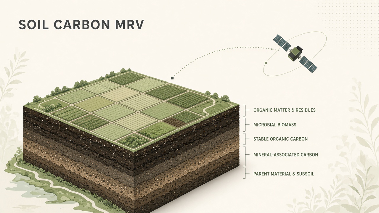
Regenerative agriculture programs and voluntary carbon markets need to know how much carbon sits in soil, and whether cover crops or reduced tillage actually increased it. Drilling and lab analysis at every field corner is too slow and too expensive. AI soil carbon measurement combines sparse ground truth with remote sensing and environmental covariates so models can estimate soil organic carbon (SOC) across whole landscapes. The approach is central to measurement, reporting, and verification (MRV) workflows that pay farmers for carbon gains. Readers following AI research in climate tech or browsing popular AI research topics will see how digital soil mapping matured from academic exercises into credit-grade infrastructure, with hard limits on what satellites alone can prove.
Why Soil Carbon Is Hard to Measure
Soil organic carbon varies sharply over meters because of tillage history, moisture, texture, and management, while carbon markets need field-scale totals with documented uncertainty. A single core through the top 30 centimeters might read 1.8 percent carbon in one furrow and 2.4 percent ten meters away. SOC also changes slowly: meaningful sequestration from cover crops or no-till may be fractions of a ton per hectare per year, buried in measurement noise if sampling design is weak. That is why credible MRV treats models as supplements to cores, not replacements. Verra's VM0042 methodology for improved agricultural land management, updated in draft guidance in February 2026, still requires soil sampling for model initialization and periodic true-up against measured stocks.
Spatial heterogeneity also creates incentives for cherry-picking. A model that maps carbon only where satellites look green will confuse biomass with deep soil gains. Auditors therefore ask for stratified random designs, paired remeasurement plots, and conservative bias correction when model predictions exceed lab results. AI can scale the map; statistics and governance scale trust.
Fusion of Lab Samples and Remote Sensing
Modern digital soil mapping stacks machine learning on top of Sentinel-2 optical time series, Sentinel-1 SAR, climate normals, topography, and legacy soil surveys, trained on georeferenced lab measurements. A 2025 PLOS ONE study by researchers including Indigo Ag scientists trained gradient-boosted models on 5,230 SOC measurements from agricultural land across 47 U.S. states. Cross-validated field-level predictions reached R2 = 0.811 with RMSE 0.041 (fraction carbon in top 30 cm). Sentinel-2 time-series summaries ranked as the strongest predictors, ahead of temperature and surface hydrology features. Public global SOC maps performed poorly on independent U.S. farm fields, underscoring why agricultural MRV needs locally calibrated models rather than off-the-shelf world soil grids.
Conservation agriculture studies push the fusion idea further. Work published in Applied Technology in 2025 combined Sentinel-1 and Sentinel-2 with XGBoost across sites in Niigata, Japan and Agbelouve, Togo. Cross-validation R2 reached 0.88 and holdout test R2 0.91, with RMSE 0.17 metric tons carbon per hectare. Vegetation indices such as NDVI, EVI, and SAVI tracked surface vigor linked to organic inputs, while radar backscatter helped under cloudy tropical conditions where optical time series gap.
| Data layer | Typical role in SOC models | Limitation |
|---|---|---|
| Soil cores and lab analysis | Ground truth, calibration, audit anchor | Expensive; sparse spatial coverage |
| Sentinel-2 optical time series | Crop vigor, residue cover, seasonal dynamics | Cloud gaps; shallow signal of deep carbon |
| Sentinel-1 SAR | Structure and moisture under clouds | Complex terrain artifacts |
| Climate and terrain covariates | Broad spatial context for extrapolation | Cannot resolve management history alone |
| In-field spectroscopy / sensors | Rapid point estimates for true-up | Requires device calibration per soil type |
Foundation Models and Uncertainty for Carbon Markets
Geospatial foundation models add pretrained spatiotemporal embeddings, but carbon crediting still demands explicit uncertainty intervals and periodic remeasurement. FoundationSoil, presented at ACM SIGSPATIAL in 2025, fine-tunes IBM and NASA's Prithvi-EO 2.0 transformer on 12,692 WoSIS topsoil samples across the continental United States. With 109 environmental covariates and stratified spatial splits to limit autocorrelation leakage, the best configuration reached R2 = 0.72 and RMSE 38.62 (units per paper). That is competitive for continental mapping with sparse labels, though field-level credit programs often need higher precision than national dashboards.
Hybrid MRV frameworks described in Wageningen University reviews combine field data, remote sensing, machine learning, and process-based ecosystem models. The model category matters less than protocol alignment: initialization samples must estimate mean and variance within strata; true-up samples must show conservative agreement between predicted and measured stock changes. AI maps that omit confidence bands invite disputes when buyers audit a single field that diverges from neighbors.
Farmer Dashboards and Incentives
Farmer-facing products translate model outputs into practice recommendations, eligibility screens, and preliminary credit estimates, usually before formal verification. Platforms in the voluntary carbon market often show NDVI trends, tillage detection, and cover-crop persistence as leading indicators while soil campaigns schedule coring. Dashboards work best when they separate "model suggestion" from "verified credit," avoiding promises that remote sensing alone locked tons underground. Transparent language about pending lab results reduces backlash when true-up lowers initial optimistic maps.
Incentives align when payments cover sampling cost and reward sustained practice, not one-year cover crop photo ops. AI reduces per-acre monitoring cost, which can widen participation among mid-size farms that previously could not afford MRV. It does not remove the need for agronomic support: the same map that estimates carbon may flag erosion risk or drought stress for adaptive management.
How MRV Pipelines Run in Practice
Operational soil carbon MRV follows a repeating loop: stratify fields, collect baseline cores, train or calibrate a digital soil map, monitor practice change with satellites, and remeasure paired plots before issuing credits. Indigo Ag's 2025 PLOS ONE framework illustrates the industry pattern: thousands of U.S. agricultural soil tests anchor a machine-learning surface, Sentinel-2 seasonal summaries capture management signals, and independent field validation prevents overfitting to a single crop year. Programs that skip stratification often discover that model error clusters in sandy corners or poorly drained lows, exactly where farmers expected payments.
Feature engineering still beats raw deep learning when labels are expensive. The same study found that engineered summaries from multi-year optical stacks outperformed dumping single-date reflectance into a network. Practitioners should budget time for covariate catalogs: PRISM or WorldClim temperature normals, SSURGO or local soil texture classes, digital elevation derivatives, and tillage dates from operator logs when available. Each layer answers a different question about where carbon might accumulate or decompose faster.
Uncertainty Quantification for Buyers
Carbon buyers increasingly ask for prediction intervals, not single map colors. Registries may require that reported stock changes include standard errors derived from paired plot remeasurement. When model true-up shows optimistic bias, methodologies force discount factors so issued credits stay conservative relative to lab data. AI teams should export quantile maps or ensemble spreads alongside mean predictions so auditors can stress-test sensitivity to drought years or cover crop failures.
Audit and Ground-Truth Requirements
Third-party auditors expect documented sampling design, chain of custody for cores, laboratory methods, and model versioning that matches the period credited. VM0042-style protocols distinguish direct measurement from model-based quantification and require paired plots at true-up so project-specific prediction error can be calculated. In-field sensor technologies may supplement lab analysis when equivalency is demonstrated, but regulators treat novel sensors skeptically until inter-lab round robin studies exist.
Greenwashing risk appears when marketers advertise "satellite-verified carbon" without naming the registry, methodology, or uncertainty band. Serious programs publish ex ante stratification maps, hold out validation fields, and ban retroactive model edits that inflate past years. AI accelerates map refresh; governance determines whether refresh is honest.
Frequently Asked Questions
Can satellites replace soil cores for carbon credits?
No for major registries today. Satellites and ML interpolate between cores and track surface proxies, but VM0042-class methodologies still require physical sampling for initialization and true-up. Models must demonstrate conservative agreement with measured stocks before issuers release credits.
Which satellites matter most for SOC AI?
Sentinel-2 multispectral time series appear repeatedly as top predictors in U.S. and global studies. Sentinel-1 SAR helps in cloudy regions. Landsat heritage feeds foundation models like Prithvi-EO through harmonized stacks. Resolution is coarse relative to tillage strips, so models blend many dates rather than one snapshot.
How accurate are AI soil carbon maps?
Accuracy depends on label density and geography. Recent agricultural studies report field-level R2 from roughly 0.72 to 0.81 in the United States and test R2 near 0.91 in paired conservation agriculture sites. Errors rise when extrapolating to new soil orders or management regimes without new cores. Treat published R2 as validation snapshots, not perpetual guarantees.
Does detecting cover crops or no-till prove carbon gains?
Practice detection is necessary but not sufficient. Cover crops increase inputs; carbon retention still depends on decomposition, climate, and baseline stocks. Models may use practice layers as features, yet crediting protocols tie payment to measured or conservatively modeled stock change, not imagery labels alone.
What is MRV in plain language?
MRV stands for measurement, reporting, and verification. Measurement is soil carbon quantification. Reporting is submitting project data to a registry. Verification is independent audit. AI mostly strengthens measurement and ongoing monitoring between expensive coring campaigns.
How do I spot greenwashing in soil carbon programs?
Ask for registry name, methodology ID, sample counts, uncertainty ranges, and whether maps were locked before true-up. Be wary of marketing that cites model R2 on national data but sells field-specific credits without field-specific cores. Credible programs welcome auditor questions; vague "AI-powered climate" slides without protocols do not.
Remote Sensing Limitations: Honest Accounting
Satellites measure the surface, not the full profile where roots and fungi store carbon meters below. Optical indices respond to biomass and residue color faster than to slow SOC accrual under no-till. Programs that credit practice adoption without eventual stock verification risk paying for visibility changes alone. The honest pitch for AI soil carbon measurement is efficiency and spatial coverage between coring campaigns, not omniscience from orbit. Regenerative agriculture coalitions that pair farmer training with MRV tend to outperform technology-only rollouts because practice change drives stocks while models document it. Tillage detection from SAR and optical change metrics helps stratify fields before coring so auditors sample both management classes rather than oversampling visibly green parcels alone.
Soil carbon AI sits at the intersection of geospatial machine learning and climate finance. Models trained on Sentinel time series and thousands of U.S. field measurements now outperform generic global soil grids for agriculture, while foundation models push representation learning further. The science is mature enough for operational MRV, but only when cores, statistics, and registry rules stay in the loop. For more on how AI handles other planetary-scale sensing tasks, explore popular AI research coverage on AI research applications from orbit to grid. Whether you are a agronomist designing coring campaigns or a data scientist benchmarking Prithvi-derived embeddings, treat every map as a hypothesis until paired measurements confirm the trend direction and magnitude.