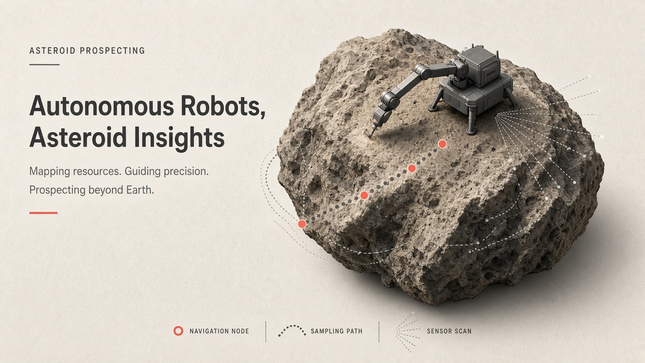
Asteroids are time capsules of primordial material and potential stores of water and metals, but they have no GPS, gravity is measured in milligals, and round-trip light time can exceed half an hour. Prospecting and sampling require spacecraft that map surfaces, rank touch-down sites, and execute touchdowns autonomously. Asteroid prospecting AI robots combine computer vision, digital terrain models, and guidance algorithms proven on JAXA Hayabusa2 and NASA OSIRIS-REx, with research pipelines extending toward NASA Psyche orbital science and future resource missions.
Space agencies, commercial asteroid mining ventures, and robotics labs share interest in closed-loop surface operations. Teams evaluating AI chatbot tools for mission planning should distinguish between autonomy demonstrated in flight and laboratory SLAM papers not yet operational. More technical explainers are listed on the EliteAI.tools blog index.
What Asteroid Prospecting AI Robots Mean in Plain Language
Asteroid prospecting AI robots are spacecraft and instrument suites that use onboard perception, machine learning, and autonomous guidance to characterize asteroid composition, select sampling sites, and execute touch-and-go or lander operations in microgravity without continuous human teleoperation. Prospecting spans remote sensing (spectrometers, magnetometers, lidar) and active sampling (touch-and-go collectors, hopping landers, coring drills). AI enters through image-based navigation, terrain classification, hazard detection, and increasingly through learned models that prioritize science-rich regolith.
Unlike Mars rovers with minutes of delay, asteroid missions must close guidance loops onboard because ground operators cannot steer a 20-minute descent in real time. Hayabusa2 dropped retroreflective target markers and tracked them with optical cameras. OSIRIS-REx used Natural Feature Tracking (NFT) against preloaded albedo maps. Both missions returned samples to Earth, demonstrating that vision-led autonomy works on rubble-pile bodies when models are trained on high-resolution approach imagery.
| Mission | Target | Autonomy highlight |
|---|---|---|
| Hayabusa2 | Ryugu (rubble-pile C-type) | Target marker optical tracking, pinpoint landing |
| OSIRIS-REx | Bennu (carbonaceous) | Natural Feature Tracking touch-and-go |
| NASA Psyche | (16) Psyche (metal-rich) | Optical nav for orbit insertion (2029) |
How the Autonomous Sampling Pipeline Works
An autonomous asteroid sampling pipeline builds a shape and terrain model from approach imagery, ranks safe touch-down zones, loads feature catalogs or markers into onboard navigation, executes a closed-loop descent with extended Kalman filtering, and triggers sampling hardware when altitude and velocity gates are met. Machine learning augments classical vision at the stages where human labeling of boulders, slopes, and albedo patterns scales poorly across bodies.
OSIRIS-REx Natural Feature Tracking and regolith sampling
OSIRIS-REx's NFT system, developed by Lockheed Martin, rendered predicted views from Maps for Landmark Navigation (digital terrain models with albedo) and matched onboard PolyCam images using normalized cross-correlation. An extended Kalman filter fused matches into state estimates during the Touch-and-Go (TAG) event. NFT delivered the spacecraft to within about one meter of the targeted site, with touch timing within 1.4 seconds of prediction, critical on a body where safe zones were far smaller than pre-launch expectations. The sampling arm collected regolith via nitrogen burst into the collector head; post-touch images confirmed successful acquisition before Earth return.
Hayabusa2 vision for low-gravity operations
Hayabusa2 combined lidar altimetry, optical navigation cameras, and dropped target markers coated with retroreflective film illuminated by a flash lamp. From about 45 meters down to hovering near 8.5 meters, the spacecraft tracked marker position in images to estimate relative velocity and attitude, achieving touchdown accuracy near one meter on Ryugu's rugged surface. Two sampling touchdowns and an impactor deployment demonstrated that marker-aided vision handles multi-minute communication delay and extremely weak gravity where traditional gravity-turn descent profiles do not apply.
NASA Psyche approach navigation and prospecting science
The Psyche mission, launched in October 2023 toward the metal-rich asteroid (16) Psyche, will use multispectral imagers for optical navigation during approach beginning about 100 days before orbit insertion in August 2029. Science orbits at multiple altitudes will map composition with gamma-ray and neutron spectrometers and magnetometers, prospecting for clues about planetary core formation. Psyche's flight software emphasizes verified guidance, navigation, and control with extensive off-nominal testing rather than experimental end-to-end deep learning flight control, but approach images will feed both human operators and future autonomous navigation research such as Gaussian-process shape estimation and SLAM demonstrated in simulation on Psyche-like trajectories.
Vision and ML for hazard detection
Modern prospecting research trains convolutional networks and U-Net variants on synthetic and real asteroid images to detect craters, boulders, and slope hazards, prioritizing recall because missing a boulder risks spacecraft safety. Lunar crater detection studies report F2-scores near 77% when optimizing for recall-heavy metrics, a deliberate parallel to asteroid hazard maps where false negatives dominate risk. For low-gravity ops, hazard maps inform not only touchdown but also plume impingement from thrusters and sampling arm reachability on rubble piles where cohesion is poorly known.
| Technique | Mission example | Strength | Limitation |
|---|---|---|---|
| Target marker tracking | Hayabusa2 | Pinpoint landing on rugged rubble piles | Requires marker deployment hardware |
| Natural Feature Tracking (NCC + EKF) | OSIRIS-REx TAG | No artificial landmarks; meter-class accuracy | Needs high-res preloaded terrain maps |
| Lidar + optical fusion | Hayabusa2 descent | Robust range in dust-limited vision | Mass and power budget constraints |
| CNN hazard segmentation | Research / future missions | Scales site ranking across bodies | Simulation-to-real gap on regolith texture |
Typical mission workflow
- Survey asteroid from safe standoff with cameras, spectrometers, and lidar if available.
- Build global shape model and high-resolution local DTMs of candidate regions.
- Rank sites for science value (hydration, grain size proxies) and safety (slope, boulder density).
- Load NFT feature catalog or plan target marker drops for final descent.
- Execute autonomous descent with onboard image processing and Kalman filter state updates.
- Trigger sampling (TAG arm, horn collector, or hopping lander) within velocity and attitude limits.
- Back away quickly, verify sample mass or volume via imaging, and begin Earth return or next site.
Regolith mechanics in microgravity
Rubble-pile asteroids like Bennu and Ryugu behave as granular media with cohesion from van der Waals forces rather than significant gravity. Touch-and-go events can mobilize more material than predicted because spacecraft thrusters fluidize regolith during final approach. OSIRIS-REx's sampling head penetrated deeper than pre-mission models expected, nearly jamming the mechanism. Autonomous robots must therefore monitor descent rates, contact torque, and post-touch images to abort if sinkage exceeds limits. Vision systems estimate surface slope from shadow geometry; spectrometers estimate hydration that correlates with grain bonding strength relevant to sampling success.
Future mining concepts and planetary defense overlap
Asteroid prospecting autonomy overlaps with planetary defense demonstration missions that require precise kinetic impactor targeting and post-impact imaging. The same NFT and SLAM research that guides sample collection informs navigation to specific boulders on a threatening body. Commercial mining roadmaps propose swarms of small prospectors, but flight heritage today is single-spacecraft architectures with redundant autonomy modes. Until multi-robot coordination flies, AI prospecting should be evaluated on single-asset sample-return metrics: touch accuracy, sample mass, and safe departure.
Published Evidence and Flight Deployments
Hayabusa2 and OSIRIS-REx provide the strongest flight evidence that image-based autonomous navigation enables regolith sampling on rubble-pile asteroids, with peer-reviewed performance metrics from TAG and touchdown events. OSIRIS-REx returned Bennu samples to Earth in 2023; Hayabusa2 returned Ryugu material in 2020, both analyzed in terrestrial labs for volatiles and organics.
Reviews of deep-space image-based navigation document centimeter-per-pixel surface models for Bennu and millimeter-scale resolution during final Hayabusa2 approaches, the data density that makes NFT and marker tracking feasible. Psyche will extend metal-world mapping with imagers and spectrometers, testing whether optical navigation pipelines tuned on carbonaceous bodies transfer to brighter, possibly metal-rich surfaces.
Commercial asteroid mining concepts remain largely pre-flight, but they inherit the same autonomy stack: prospecting spectrometry plus hazard-aware touchdown. JAXA's MEGANE spectrometer on Hayabusa2 and OSIRIS-REx OVIRS maps fed site selection before autonomy modes armed. Until in-situ resource demonstrations fly, claims about autonomous mining robots should cite Hayabusa2 and OSIRIS-REx heritage and clearly label simulation-only AI steps such as reinforcement-learned hop planners that have not flown on deep-space missions.
Deep-space optical communication demonstrations on Psyche (DSOC) are separate from surface autonomy but reduce latency for future missions that might loop human oversight into sampling decisions when bandwidth allows. For now, onboard AI remains the bottleneck solver for the final seconds before regolith contact.
Limits, Risks, and Ethical Guardrails
Asteroid autonomy fails when preloaded terrain models disagree with actual regolith mobility, when dust clouds obscure markers or features, or when deep learning hazard detectors trained on lunar imagery mis-segment rubble-pile textures. OSIRIS-REx discovered Bennu's surface far rockier than pre-launch models, forcing late trajectory redesign; autonomy software succeeded only because approach mapping updated catalogs before TAG.
- Communication delay: Ground cannot micromanage touchdown; onboard fallbacks are mandatory.
- Plume-surface interaction: Thrusters disturb loose regolith unpredictably in microgravity.
- Planetary protection: Sampling must avoid forward contamination and preserve sample science.
- Space resource ethics: Prospecting data may precede legal frameworks for extraction.
- Dual-use navigation: Same vision stacks support proximity operations and deflection missions.
Ethical guardrails include open release of shape models after sample return, transparent reporting when autonomy modes override operator commands, international coordination on heritage body protections, and resisting hype about commercial mining timelines before environmental and orbital-debris impacts are studied. AI prospecting should prioritize planetary science and planetary defense knowledge before extractive economics.
Who Should Use This and Who Should Wait
Mission designers building sample-return or deflection demonstrators, GNC engineers adapting NFT or marker tracking, and robotics researchers with access to asteroid shape models should invest in vision-led autonomy now. Commercial mining startups without launch contracts should treat AI prospecting slides as roadmap items contingent on flight heritage, not current capability.
| Audience | Recommendation | Caveat |
|---|---|---|
| NASA/JAXA mission GNC team | Reuse NFT or marker pipelines with new DTM workflows | Re-map surface late if rubble exceeds models |
| Psyche science planning | Integrate optical nav imagery with spectrometer site picks | Metal-rich albedo may differ from Bennu/Ryugu |
| Robotics ML researcher | Train hazard CNNs on synthetic regolith plus mission archives | Flight software needs deterministic fallbacks |
| Asteroid mining investor pitch | Wait for in-situ demonstration beyond sample return | Sample return proves touch, not industrial extraction |
Frequently Asked Questions
What is Natural Feature Tracking on OSIRIS-REx?
NFT matches onboard camera images to rendered views from preloaded digital terrain and albedo maps using normalized cross-correlation, then updates spacecraft position with an extended Kalman filter during touch-and-go. It guided TAG to roughly one meter from the aim point without deployed markers.
Why did Hayabusa2 use target markers instead of NFT?
Retroreflective markers provided high-contrast landmarks on Ryugu's dark, uniform surface when natural feature correlation was unreliable at final descent altitudes. Optical cameras tracked markers with flash illumination for centimeter-class relative navigation.
Does NASA Psyche use AI autonomous sampling?
Psyche is an orbital mapping mission without a sample-return touchdown; it will use imagers for optical navigation during approach and science orbits starting in 2029, not regolith collection robots. Psyche informs metal-asteroid prospecting science rather than touch-and-go autonomy heritage.
How is regolith sampled in low gravity?
OSIRIS-REx used a touch-and-go arm with nitrogen gas to stir material into a collector; Hayabusa2 fired a tantalum projectile into the surface and captured ejecta in a horn. Both required autonomous velocity control because escape velocities are centimeters per second.
Why is vision critical in low-gravity asteroid ops?
Weak gravity makes inertial navigation drift dominate quickly; optical measurements of surface features or markers directly constrain relative position during slow descents where lidar and cameras overlap. Ground teleoperation cannot close the loop fast enough at interplanetary distances.
Where does machine learning help beyond classical NFT?
ML classifies terrain hazards, predicts science-rich regolith from spectra, and accelerates shape-model fusion in research SLAM pipelines, but flight-proven sampling still relies on geometric feature tracking and Kalman filters validated on OSIRIS-REx and Hayabusa2. Treat deep learning as augmentation until new missions certify onboard networks.
Conclusion
Asteroid prospecting AI robots combine remote sensing with touch-and-go autonomy proven on Hayabusa2 and OSIRIS-REx: target markers and Natural Feature Tracking solved low-gravity navigation, regolith sampling hardware captured material under tight velocity gates, and NASA Psyche will extend orbital prospecting of a metal-rich body with optical navigation in 2029. Machine learning increasingly ranks hazards and science sites, yet flight-critical loops remain explainable geometric estimators until new missions certify learned components. Teams should build on returned sample mission data, update terrain models continuously during approach, and separate demonstrated sample return from commercial mining autonomy that still awaits its first operational demonstration.