Top AI tools for geographic data
-
 Ultimaps Map visualization tool made for humans
Ultimaps is an intuitive map visualization platform that allows users to create color-coded and interactive maps instantly by importing data from Excel, Google Spreadsheet, or Notion, with AI-assisted map creation capabilities.
- Freemium
- From 17$
-
 GeoComm GIS Solutions for Enhanced Emergency Response and Public Safety
GeoComm delivers advanced GIS mapping software and services designed to improve emergency response, school safety, and data management for public safety agencies and educational institutions.
- Contact for Pricing
-
 Pelias Geocoder A modular, open-source search engine for our world
Pelias is an open-source geocoder that transforms addresses and place names into geographic coordinates and vice versa, powered by open data and built on Elasticsearch for fast global search.
- Freemium
-
 Exploring Data Interactive Data Visualizations with Open Data and Open Source Tools
Exploring Data is a platform showcasing interactive data visualizations created using open data and open source tools, featuring various network graphs, 3D globes, and geographic maps.
- Free
-
 Cadmapper Get instant CAD files for any location on earth
Cadmapper transforms data from public sources like OpenStreetMap, NASA, and USGS into neatly organized CAD files, saving hours of routine drawing for designers, architects, and illustrators.
- Freemium
-
 DB-IP The ultimate resource for IP address geolocation and network intelligence
DB-IP provides comprehensive IP address geolocation and network intelligence services through API and database solutions, offering accurate location data, threat assessment, and localization features for businesses worldwide.
- Freemium
- From 9$
-
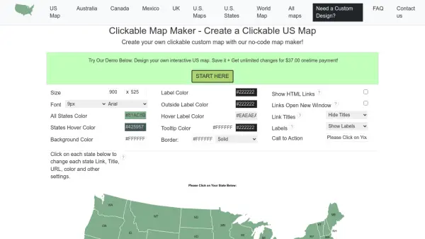 CreateAClickableMap Create Interactive Clickable Maps Without Coding
CreateAClickableMap is a no-code platform for building customizable interactive maps, including US state maps, with clickable regions, popups, and embeddable code for websites.
- Pay Once
-
 GeoDataSource Comprehensive World Cities Database for Developers and Businesses
GeoDataSource provides a comprehensive world cities database with 3 million city features across 249 countries, offering accurate location data including names, coordinates, and administrative divisions for integration into various database systems.
- Freemium
-
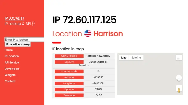 IP Locality Free and Premium IP Location API Service
IP Locality provides a free and premium IP location API service that delivers detailed geographic information for IP addresses, including city, country, coordinates, and timezone, with support for multiple programming languages.
- Freemium
- From 9$
Explore More Tags
-
compliance tools 77 tools
-
GDPR 57 tools
-
legal research 48 tools
-
productivity 236 tools
-
document interaction 31 tools
-
content analysis 116 tools
-
audio transcription 72 tools
-
video transcription 81 tools
-
meeting minutes 20 tools
Didn't find tool you were looking for?