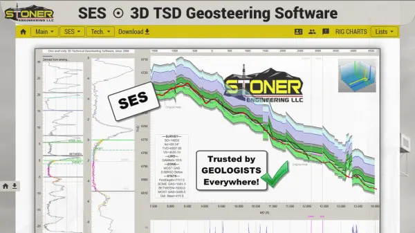
What is SES 3D TSD Geosteering Software?
SES 3D TSD Geosteering Software provides petroleum professionals with cutting-edge capabilities in horizontal drilling by utilizing true 3D vector geometry for precise wellbore-to-stratigraphy correlation. Unlike conventional 2D approaches, SES translates LWD signals into 3D wellbore and bed orientations, revealing accurate stratigraphic detail crucial for intercepting hydrocarbon-rich zones.
With a robust geosteering guidance engine and integrated suite of exclusive petroleum engineering features, SES enhances the accuracy of mapping, interpretation, and decision-making across all phases of reservoir development. Trusted by industry leaders for over 18 years, SES is recognized for its reliable, science-driven approach to technical geosteering in complex subsurface environments.
Features
- 3D Vector Geometry Correlation: Enables highly-accurate positioning between wellbore and stratigraphic beds.
- True Stratigraphic Depth Analysis: Delivers detailed visualization and understanding of structural geology.
- Geosteering Guidance Engine: Offers advanced algorithms for wellbore navigation and interpretation.
- Integrated Petroleum Engineering Technologies: Combines multiple exclusive principles for improved results.
- Real-Time Data Processing: Supports timely and responsive drilling decisions with updated correlations.
- Industry-Proven Performance: Validated by 18 years of use and feedback from hundreds of companies.
Use Cases
- Optimizing horizontal well steering in complex geological formations
- Real-time identification and targeting of payzones during drilling operations
- Detailed 3D geological interpretation for reservoir development planning
- Reducing uncertainty in subsurface mapping for hydrocarbon extraction
- Supporting multi-disciplinary teams with advanced well log correlation