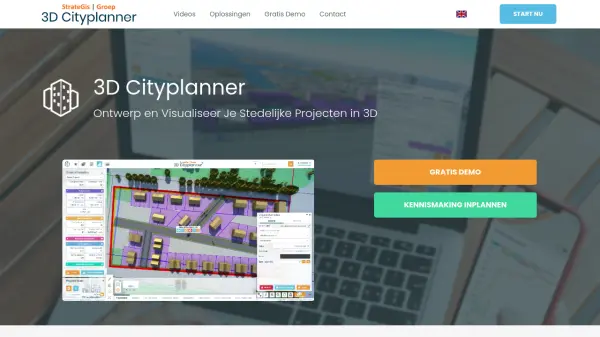
What is 3D Cityplanner?
3D Cityplanner is a comprehensive platform designed for urban development and spatial planning, with a focus on the Netherlands. Offering extensive real-time access to geographical, cadastral, and 3D building data, the platform allows users to seamlessly analyze, design, and visualize urban environments. AI-driven tools facilitate the rapid generation and adjustment of mass studies, master plans, building variants, and infrastructure, ensuring accurate and efficient project development.
The platform supports a wide range of features such as automated building and apartment generators, 4D project planning, comparative analysis dashboards, and energy potential assessments. Users can create and share detailed digital twins, incorporate BIM/IFC and SketchUp models, manage lighting and underground utilities, and evaluate land use and financial feasibility. Tailored to the needs of governments, developers, independent professionals, and academics, 3D Cityplanner streamlines decision-making and enhances collaboration throughout every stage of urban planning.
Features
- AI Building Generator: Automatically create building models based on input parameters such as plot size or dwelling preferences.
- 3D Visualization: Real-time, high-detail rendering of cities and environments using multi-source data including LOD1 and LOD2 models.
- Comprehensive Data Layers: Access to cadastral, demographic, geographic, 3D BAG and BGT data for detailed project analysis.
- Variant Comparison: Seamlessly compare multiple design or planning options within projects.
- Project Planning in 4D: Visualize phased development, including renovations and demolitions, over time.
- Financial Module: Calculate residual land values and perform in-depth property exploitation analyses.
- Solar Potential Calculation: Assess energy yield based on roof angle and orientation for every location.
- Import Functionality: Integrate detailed models from BIM, IFC, SketchUp, and CityGML.
- Digital Twin Sharing: Share customized 3D urban models and visualizations via bookmarks.
- Analysis Dashboards: Create, visualize, and assess land, property, and local feasibility studies.
Use Cases
- Designing and visualizing new urban developments or master plans.
- Analyzing zoning, cadastral, and environmental data for site selection.
- Comparing architectural building variants and assessing redevelopment options.
- Calculating solar energy potential for rooftop installations.
- Performing detailed financial and land-use feasibility studies.
- Simulating infrastructure changes, such as lighting or drainage systems.
- Sharing interactive urban models with stakeholders for collaborative planning.
- Academic research and teaching in urban planning and spatial analysis.
FAQs
-
Can users import external 3D models into the platform?
Yes, users can import BIM, IFC, SketchUp, 3d Max, and CityGML models for detailed visualization within their projects. -
Is a free demo or trial available?
Yes, the platform offers a two-week free trial without requiring payment details. -
What geographic area does the platform primarily cover?
The platform is focused on the Netherlands, offering detailed local datasets and 3D building data nationwide. -
Who can benefit from using the 3D Cityplanner?
Professionals in urban planning, governmental organizations, architects, project developers, independent entrepreneurs, researchers, and academia can utilize the platform.